

index
16 Apr 2022: Colour Bar4 as a Jupyter Notebook
15 Apr 2022: QGIS3: bcCBar4
02 Mar 2021: Loading sketches from Arduino IDE to ESP-01S through UNO
03 Sep 2020: LO Writer: Save all images to files
13 Sep 2019: New look website
11 Dec 2019: QGIS3: User defined symbol shapes and sizes
08 Sep 2019: QGIS3: Watersheds and streams networks
25 Aug 2019: QGIS3: Image Legend widget
04 Aug 2019: QGIS3: How to use QML Forms
13 Jun 2019: QGIS3: bcMultiStyles3
13 Jun 2019: QGIS3: bcSwapYZ3
12 Jun 2019: QGIS3: bcCBar3
11 Jun 2019: QGIS3: bcclr2tbl3
03 Jun 2019: QGIS3: bcStackP3
01 Jun 2019: QGIS3: bcGenRNDSurveyData3
23 May 2019: QGIS3: bcSaveqml3
26 Mar 2019: LO Calc: Save all sheets in separate files
16 Mar 2019: QGIS3: FGDC symbols
11 Mar 2019: HTML: A simple In-Page Javascript Search Engine
10 Feb 2019: QGIS2: Colour Scale Bar for One-Band Rasters
01 Jan 2018: QGIS3: How to install python plugins?
18 Mar 2017: QGIS2: Import vector layer's colour symbology from MapInfo
01 Oct 2016: MSWin10: desktopSS
01 Jul 2016: HTML: Interactive 3D
01 Apr 2016: QGIS2-MSExcel: How to compute volumes?
18 Jan 2016: Photogrammetry: Presentation Test Results
04 Jun 2015: VB6: Visual Basic 6 runtime and specific libraries
02 Dec 2009: Microsoft XP: AWD Converter
 Colour bar for One-Band Rasters: this Jupyter Notebook creates a colour bar image file in svg format from a QGIS V3.x qml file of a coloured 1-band raster. more... Colour bar for One-Band Rasters: this QGIS Processing algorithm creates a colour bar image file in svg format for a coloured 1-band raster. Use the created colour bar as legend in print composer. more...
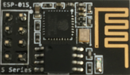 Use Arduino UNO as a pass-through to load programs from Arduino IDE to ESP8266 more...
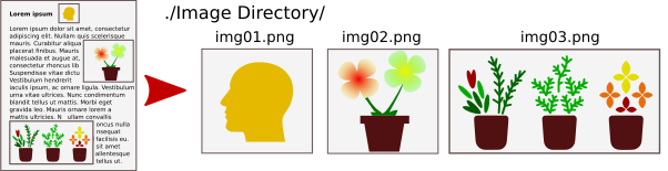 Save all images in a LibreOffice document to their own png file in your image folder. more...
 Hello and welcome to our new look website. All pages are now accessible from the home page and the old site structure has not survived.
 A QGIS 3.x workflow to style a point vector layer with symbols of different shapes and sizes, depending on fields values. more...
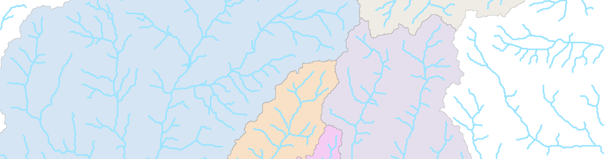 Watersheds delineation with SAGA and QGIS: Simple workflow to create watersheds and streams networks from SRTM data. more...
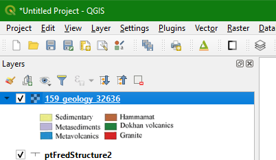 Use a sidecar PNG or JPG file to add an image to a raster layer in QGIS Legend pane. The image generally represents the legend associated with the raster map. Click on the image to display the full size image in your favourite image editor. more...
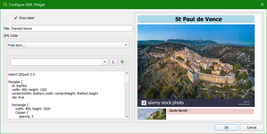 An introduction to Qt Markup Language (QML) for form design in QGIS versions 3.4 and above. QML forms were introduced in later version of QGIS 2.x branches and are fully functional in QGIS 3.x branches. Learn the basics of beautiful forms design. more...
 Load/Save .qml in multi-styled layer. This QGIS V3.x Processing algorithm loads/saves multiple styles in qml's to/from a QGIS layer. The styles are saved as sidecars in the same directory of the layer file, by default. Loading styles can be done from the sidecars or from a directory. more...
 Create Z-coord from Y-coord. This QGIS Processing algorithm creates a 3D vector by setting Z-coord to Y-coord and setting Y-coord to a constant.
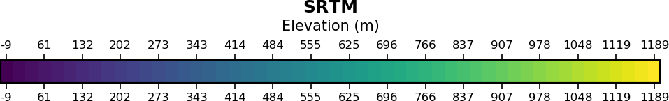 Colour Scalebar for One-Band Rasters: this QGIS Processing algorithm creates a colour scalebar image file (svg and, optionally, png) for a coloured 1-band raster. Use the created colour scalebar as legend in print composer. more...
 Style a raster with Surfer .clr: this QGIS Processing algorithm styles a one-band raster layer using Golden Software Surfer colour ramp files (.clr). more...
 Stacked profiles from point layers. This QGIS Processing algorithm creates stacked profiles from a point layer having the following fields: Fiducial, line and data. Stacked profiles are created in a new line layer.
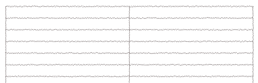 Random data surveys. Just for fun! This QGIS Processing algorithm creates dummy surveys with line, tie-lines and noisy data. Lines and tie lines are not straight lines: noise is added to the X- & Y-coords. Data is a periodic function with lots of noise and spikes. more...
 Save style files (.qml): This QGIS V3.x Processing algorithm is used to save the style information, in qml files, of many layers at once. more...
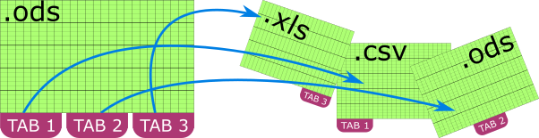 LibreOffice Calc macro to save all sheets from a spreadsheet in separate files (xls, xlsx, ods or csv). Filenames are automatically generated from sheets name. more...
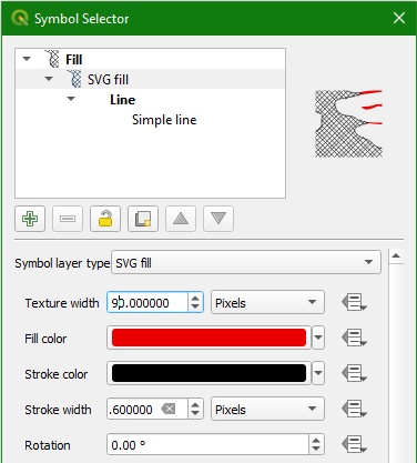 FGDC fill geology symbols library for QGIS 3.x.
 Tutorial on how to develop a simple search engine in Javascript to locate structured records stored in a single html page. No server-side code. more...
 For QGIS version 2.x only. This QGIS plugin creates a colour scale bar image file (png) for a coloured 1-band raster. Also works for QGIS native colour schemes thanks to Thomas Wahlmüller. Use the created colour scale bar as legend in print composer. more...
 Different methods to install a QGIS python plugin are explained. more...
 A 9-step method to style a field in QGIS to its colour style in MapInfo. more...
 Microsoft Windows10 desktop slideshow replacement. more...
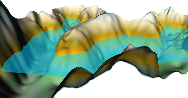 A step-by-step recipe to compute volumes when common volume routines do not work. more...
 Selected results from a photogrammetry survey done with a gyrocopter and standard camera equipment. more...
 With Microsoft having forgotten Microsoft Visual Basic 6 (VB6) it is sometimes necessary to install specific libraries (OCX) in order to have a VB6-based software run without having to create an installation package for the application. The .msi package provides standard VB6 ocx'es. more...
 AWDConv: Convert Microsoft AWD fax format to TIFF images. For MSWindows XP/Vista.
